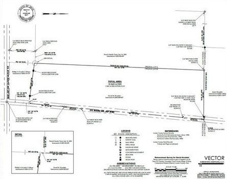
Boundary Retracement Survey
A boundary retracement survey is a procedure by which a Professional Land Surveyor establishes the corners of a parcel of land. The determinations made by boundary retracement surveys are reliant on the interpretation of evidence. “Monuments over measurements” is an old adage curated by Professional Land Surveyors. The turn of phrase examines the conundrum that there is limited acreage on the surface of the earth and everyone’s private property must fit. The bearings and distances that are declared in private land deeds are only a part of the determination; the evidence found in the field is also an important part of the puzzle. Once a boundary survey is completed, the client will have every corner of their property marked by a monument that was either found or set by the surveyor. A map of the survey, known as a plat, is then drafted and provided to the client. The plat will show all of the corner marking monuments, whether found or set, the bearings and distances between them, and all other pertinent information used to establish the corners of the parcel. The client also has the option of having a legal description of the property's boundaries written by Vector Surveying, which can then be placed on an updated deed. Get an estimate >>
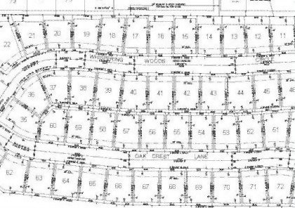
Lot Split Survey (Subdivison Survey)
A lot split is the legal division of any parcel of land into two or more lots. Lot splitting can be categorized as a minor subdivision or a major subdivision - each defined by the county where the subdivision is being performed. Considerations are made concerning topography and accessibility when applying to split a lot of land. Mathematically, a 10 acre parcel can be split 4 times for five 2 acre lots. The plan makes sense, but a practical evaluation may prove the proposition to be faulty. Almost all lot splits and subdivisions require governmental review and approval. I need this >>
ALTA Land Title Survey
A land title survey is made for a title company and/or lender to allow the issuance of a title or mortgage insurance. Clients, who are usually seeking an ALTA survey for a commercial property, must specify the data they require by filling out a checklist known as "Table A". During the survey, our professionals will produce a map drawn to American Land Title Association specifications and the information the client requests. An ALTA Land Title Survey provided by Vector Surveying is guaranteed to meet the requirements for an ALTA/ACSM Land Title Survey as detailed by the American Land Title Association, The National Society of Professional Surveyors, and The American Congress on Surveying and Mapping. Quote me >>
Elevation Certificate
An elevation certificate is a document required by the National Flood Insurance Program. Property owners always have the right to purchase an elevation certificate for their parcels - potentially resulting in the reduction of their flood insurance premiums. An elevation certificate documents the elevation of the lowest floor of your house or building relative to the ground surrounding it. If a structure is built in a high-risk flood zone it is critical that the land owner purchases an elevation certificate. Before contacting a Professional Surveyor at Vector, call your municipal government and ask them if there is an elevation certificate on file for your property. I need an elevation certificate >>
Topographic Surveys
A topographic survey is when all items (trees, light poles, catch basins, water main valves, building corners, edges of asphalt, ground points, etc.) are horizontally and vertically located and then mapped in a CAD program. The topographic surveys that Vector Surveying provides are most commonly used for the design and planning of construction projects such as a water main replacement, a building addition, or the installment of subsurface drainage in a farm field. Get a topographic survey >>

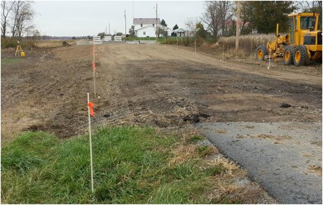
Construction Staking
Construction staking is set after a building project has been designed. The staking provides guides for constructors charged in erecting the proposed features. An excellent example of staking for construction can be observed during the creation of a road. Before a road is set there are proposed storm structures that must be installed. Finally, the proposed curb is installed and asphalt is set into place. So what is the staking good for? Survey stakes enable engineers or builders to painlessly create catch basins at their proper locations and elevations. Essentially, the construction staking ensures that when the proposed curb is installed around the catch basins that everything will work as the designer intended. Let's work together >>